|
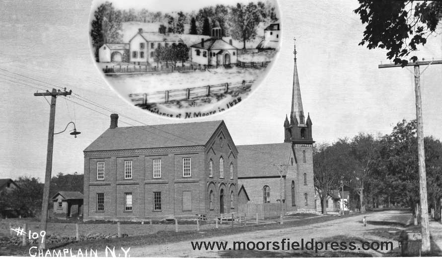
Church
Street
in
Champlain
Village
shows
the
old
Noadiah
Moore
house
and
1815
school
building in an 1828 view as well as a later
view circa 1908 showing School No. 1 and
Methodist Church, both built around
1875. Photo courtesy Special
Collections, PSUC and inset courtesy the
Clinton County Historical Association.
Essay: A History of the
Settlements and Early
Settlers
in Champlain
Town
(Champlain,
Coopersville, Perrys Mills and Rouses
Point)
The
2011 calendar presents a comprehensive history of
the founding
of the four main settlements in the Town
of Champlain: Champlain Village,
Coopersville,
Perrys
Mills
and
Rouses
Point.
The
thirteen
large format photographs keep to this theme and
present views of buildings and country road scenes
from these communities. This is the first
time in recent times that a complete history of
Champlain Town has been
given.
The town was
founded after two tracts of land
were granted: the Moorsfield Grant (Smith
and Graves Patent) encompassed one third of the
town and was issued to Pliny Moore. Shortly
afterwards, the Canadian and Nova Scotia Refugee
Tract was issued to Canadian refugees who had
served in Congress' Own regiment in 1776 and
after.
Pliny
Moore settled Champlain in 1788 and 1789 and
Jacques Rouse came to the lakeshore
along
with
many
refugees
a
few
years
earlier.
By
1800,
many
more
settlers
such
as Ebenezeer Cooper and George Perry came from the
New England states and made settlements that now
bear their names: Coopersville and
Perrys Mills.
==================================
The
following
is an abridged version of the essay.
Considerably more information is found in the
calendar.
Historic
Essay
Champlain
Town, now called the Town of Champlain, has a rich
history. The town’s settlement dates to the
end of the Revolutionary War when settlers from
both sides of the border were allocated land by
the State of New York after serving in the
army. Starting in 1782, settlers came to the
lakeshore and to the interiors of the town to take
advantage of its untapped natural resources such
as agriculture, timber and water power.
Within 20 years, the principal villages and
hamlets had been settled and Champlain was
growing.
The
Moorsfield
Grant
To
raise
regiments
for
the
defense
of
New
York
during
the
Revolutionary
War,
the
state
legislature,
on
March 20, 1781 and March 23, 1782, passed laws
that appropriated land, depending on rank and time
of service, to men who enlisted in the army.
Pliny Moore, of Kinderhook, New York (near
Albany), had enlisted in 1776 at the age of 17 and
re-enlisted several times to earn several thousand
acres of land. By July 10, 1783, twenty one
soldiers in his regiment (later 17) were allocated
land and Moore was appointed to find
unappropriated land in the state, survey it and
arrange for the balloting of the lots. After
several unsuccessful attempts at finding land in
western New York, he chose land in upstate New
York in wilderness that was almost inaccessible by
land. He applied for the 11,600 acre plot
now called the Moorsfield Grant (or Smith and
Graves Patent named after the first two names on
the application). He surveyed it in the
spring of 1785 and in the fall of 1786, he divided
the grant into 119 lots and surveyed each
lot.
On
February
6,
1787
the
“Great
Deed”
was
made
by
the
state
and
Moore
obtained
(and
purchased
from other soldiers) 3,820 acres of land (40 lots)
out of the 11,600 acres in the patent. In
January of 1788, while still living in Kinderhook,
Pliny petitioned the state legislature to create
the Town of Champlain as well as Clinton County to
enable better facilitation of legislative and
judicial matters as his settlement was so far away
from Albany. On March 7, 1788, “Clinton
County” and the “Town of Champlain” were created
as well as the towns of Plattsburgh, Willsboro and
Crown Point. The law stated, in part, “And
that all part of the county of Clinton, laying to
the northward of the town of Plattsburgh, …shall
be, and hereby is erected into a town by the name
of Champlain.” At the time of its creation,
Clinton County encompassed the present counties of
Clinton, Essex, Franklin and St. Lawrence.
The town extended to Vermont and included Alburg
and Isle La Motte. This is reflected in the
1790 Census.
On
May
23,
1788,
Pliny
came
to
his
Champlain
settlement
with
several
workers
and
land
proprietors
and built a sawmill near Perrys Mills and in
February of 1789 came back with his wife and
newborn son Noadiah and settled permanently in
what is now the Village of Champlain.
Elnathan Rogers and Samuel Ashmun, two of the
original soldier proprietors also settled
permanently and several settlers came around this
time after buying other soldiers’ rights.
The earliest settlers were William Beaumont,
Joseph Rowe, Caleb Thomas and Murdock
McPherson. The 2007 and 2008 Champlain
Historic Calendar essays describe the settlement
of Champlain Town in detail.
For
the
next
several
years,
a
small
influx
of
settlers
came
and
settled
on
the
lots
in the Moorsfield Grant and the Refugee Tract
within the Town. Land adjacent to the
lakeshore and along the Great Chazy River was
considered most valuable. There were many
location on the Great Chazy River where sawmills,
grist mills and fulling mills could be
built. But the first large scale settlement
would not occur for another 10 or 15 years and
land was sold and resold many times before people
settled permanently on it. Starting around
1800, hundreds of settlers came from Connecticut,
Massachusetts, Vermont and central New York to
settle on the wilderness lands that the original
patent holders sold. The Hubbells came from
Lanesboro, Mass, the Hayfords from Saratoga
County, NY, the King family (settlers of Kings
Bay) from Pittstown, NY, the Stetsons came from
Cornwall, Vt, George Perry came from Middletown,
Conn., Johnson Chapman came from Vermont, and the
Pettingers and Rochesters came from England.
Only between the years 1810 and 1814 did the
population of Champlain shrink, this being due to
the war.
The
Canadian
and
Nova Scotia Refugee Tract
In
late
1782
or
in
1783,
many
French
and
Scottish
soldiers
and
their
families
came
from
Canada and settled on the lakeshore and around the
Great Chazy River. These soldiers had served
in Brig-General Moses Hazen’s Canadian regiment
starting in 1776. The troops were part of
the regiment known as Congress’ Own because they
were raised by an act of Congress on January 20,
1776 and not by New York State.
Because these Canadians sided with the
Americans, they lost their land in Canada and were
forced to leave by the British after the Americans
lost control of Quebec later that year.
Because of the refugees’ predicament, the
State of New York passed a law on May 11, 1784,
that granted them land in what is called the
“Canadian and Nova Scotia Refugee Tract.”
The tract, 132,000 acres in size, encompassed the
towns of Champlain, Mooers, Altona, Chazy and
parts of Dannemora and Saranac. The tract
was divided into 520 lots of 80 or 420 acres each
and distributed among 226 soldiers. The
amount of land received by the soldier was based
on his rank and time served (similar to how Pliny
Moore and his soldiers were allocated land).
:
:
:
The
Village
of
Champlain and Vicinity
The
Village
of
Champlain
lies
entirely
in
the
4.25
by
4.25
mile
wide
Moorsfield
Grant.
The
original
settlers in and around the village were Pliny
Moore, Elnathan Rogers, Samuel Ashmun, William
Beaumont, Caleb Thomas and Joseph Rowe.
When
Pliny
Moore
came
back
to
Champlain
in
February
of
1789,
he
lived
in
a
log
hut on the Great Chazy River where the old bank
building or Knights of Columbus Hall is today and
shortly afterwards, built a frame house on the
hill where the Clark Funeral Home is
located. The 1798 tax assessment described
his property: “Pliny Moor, No. 2, Owner and
occupant of a wood house 40x30 ft., 1½ stories,
located “on the North Bank of the Great River
Chazy,” seven windows 4x2 ft., one 3½x2 ft., one
2x2 ft., two 3 1/3 x ½, two 1 1/3 x 1, and
one 3 x 2/3 ft.; house “Old in Tolerable
Repair.” Also “1 Stone Smoke & ash house
14x8, 1 Wood N Y house 8x6, 1 Wood Goose house
14x12.” One acre, value $600.”
:
:
:
Coopersville
a.k.a. “Mooers Mills” and “Corbeau”
Coopersville
is
named
after
Ebenezer
Cooper
who
settled
on
the
bank
of
the
Chazy
river
in
1817. In its earliest days, the Coopersville
area was known as “Corbeau” as well as “Mooers
Mills”. The settlement grew around the
intersection of the Great Chazy River and Corbeau
Creek, called in 1797 “Riviere au Corbeau” by the
French refugees living nearby. It is thought
that the Corbeau name is derived from the color of
the waters in the creek. The waters are very
muddy and dark which is similar to a crow or
raven’s color. The French translation for
“crow” is corbeau and it might have been referred
to as a “river of black waters or raven river.”
In 1810,
Ebenezer Cooper, who originally was from Vermont,
settled in Champlain Town after living in Chazy a
short while. He settled on the west side of
the river where his only neighbors were Eseck
Angel and families named Ford and Broadwell.
Cooper later moved to the river shore in 1817
after buying Benjamin Mooers’s land. He
bought lots 120, 121 as well as the sawmill and
grist mill for $3,200 ($44,000 today).
Presque
Asselin
was
one
of
the
refugees
who
settled
permanently
in
Champlain.
When
he
came
to
town,
he built a log house on the Great Chazy River.
No one knows exactly where he settled but it
was probably on either lots 90 or 109 which is
along the river in the Moorsfield Grant (a map
drawn by Pliny Moore in 1786 shows several huts
built along the river; one of these is likely
Asselin’s; see the aerial photo for the hut
locations). Asselin was allocated 500
acres of land and purchased part of lot 3 from
Pliny Moore on August 5, 1788. Pliny also
sold part of lot 90 to Asselin, which included the
river frontage, but Presque sold this land to a
Trahan in 1790. Presque lived on part
of lot 3 on what is now the Mason Road near Clark
Road north of St. Joseph’s Church. It is
likely that Asselin could speak English as he was
active in town politics since its inception.
In 1793, the annual town meeting was held at his
house and he was elected a commissioner of the
highways along with four others. By the 1830
census, the name of Asselin had been changed to
Ashline. Many of Presque’s descendents
still live in the area.
:
:
:
Perrys
Mills a.k.a. “Schieffelin’s Mills”
The
settlement
of
Perrys
Mills
started
around
1800
but
the
lot
ownership
dates
back
to
the
balloting of lands. After the original
balloting of lots in the Moorsfield Grant in
February of 1787, lot 19 went to David Perry (and
later to James Rice), lots 20 & 21 went to
Pliny Moore and lot 39 went to Elnathan Rogers.
The ownership of many of the refugee lots,
however, would become marred in controversy as
ownership of land was sometimes claimed by more
than one person because of questionable
deeds. The massive 420 acres of lot 16 in
the refugee tract went to Captain Clement Gosselin
but was purchased by Peter Sailly of
Plattsburgh. He sold the land along the
Chazy river (60 acres in the southeast corner) to
Jacob Schieffelin who then sold it to his brother
Thomas for $1.00. The Schieffelin’s land
ownership in Champlain was marred in controversy
for almost 20 years. (Thomas Schieffelin
Jonathan Schieffelin)
In
1800,
George
Perry
and
his
wife
settled
west
of
Champlain
near
Mooers
after
buying
105
acres of land from Benjamin Mooers for $210.
Perry was born in 1777 and lived in Middletown,
Connecticut, previous to his arrival here.
After arriving, he became interested in
running a mill and in September of 1803 asked
Pliny Moore if he could lease his mill. He
noted that the Platts of Plattsburgh had this
arrangement with other people. An
agreement was made and in September of 1806, Perry
wrote that he would continue Moore’s clothing
business like he did the previous season. By
1811, Perry had entered politics in Mooers and was
supported as a Republican running for the State
Assembly. In 1814, he was one of three
appointed by the Republican Committee to represent
Mooers and promote the Republican candidates that
were to be nominated.
:
:
:
Rouses
Point
a.k.a.
“Point
Moore”
The fist British proprietor of the northern
lakeshore now known as Rouses Point was Colonel
Gabriel Christie, a British soldier living in
Quebec. A description of the land he purchased
is as follows: “…a tract of land extending from the
45th degree of northern latitude, to one league [3
miles] south of the great river Chazzy, on the west
side of Lake Champlain, by three leagues [9 miles]
in depth, together with the island LaMotte, opposite
to the said tract.” Christie had
purchased this land in 1766 or earlier but the State
of New York, after the Revolutionary War had ended,
contested his claim. When Pliny Moore chose
the location of the Moorsfield Grant, he purposely
put it three miles to the west of Lake Champlain
(which appears to still be on Christie’s land).
Rouse was likely born in Chipoudy, Nova Scotia in
1753 and was living in Quebec City in September of
1759 when it was conquered by British General James
Wolfe during the French and Indian War.
By his own admission he had a very eventful
service in the American Army during the
Revolutionary War. In a sworn statement to
Judge Pliny Moore in 1818 when he was 65, he stated
his military service: “That he joined the American
Army in Canada in the fall of the year 1775 as a
Volersieer. That he entered the City of Quebec
with General
Rouse
supposedly
had
three
wives
and
a
total
of
26
children
but
only
eight
of
them
survived to adulthood. His first wife was
Clara Therese Olivier, adopted niece of Major
Lawrence Oliver (or Laurent Olivier) who he
married at age 14 in 1780 in Albany, New York
(Hazen’s regiment was at this time in various
places in New York as well as in
Pennsylvania). Oliver (Olivier) also
accompanied Rouse to this area and settled on the
lakeshore. Rouse’s oldest child was Lawrence
but he drowned in the lake at the age of 14 around
1800. Other sons were Lewis (born around
1792), Solomon M. (Simeon?, born in 1795 and died
in 1860 in Wisconsin) and Michael. Daughter
Clara married Eddy Thurber of Rouses Point.
Other daughters were Julia and Sophia. His
last surviving child was Mary who married Charles
White of Rouses Point. She died in 1868 and
is supposed to be in Maple Hill Cemetery (note
that there could be more children of his not
listed here). Grandchild David White
(1831-1902) was the engineer in charge of building
Fort Montgomery and Eleanor (White) Luck was his
sister. David was unmarried but Eleanor had
children whose descendents may still be in the
area. Rouse’s son Lewis settled in Green
Bay, Wisconsin, after serving in the War of 1812
with his brothers Michael and Solomon, and worked
for the American Fur Company. Hugh McLellan
corresponded with a few descendents of Jacques
Rouse between the 1920s and 40s. At the
time, there did not seem to be any of his
descendents living in Champlain Town.
:
:
:
The
Boundary
Line
of the 45th Parallel at “Point Moore” (Rouses
Point)
The
boundary
of
the
United
States
in
Champlain
Town
had
been
a
source
of
contention
for
the first half of the 19th Century. This was
due to the inaccurate determination of the 45th
parallel which was the stated boundary between New
York and Quebec. Once the boundary was
inaccurately marked, numerous land surveys based
on this location were made and more survey errors
propagated. This culminated with the
building of Fort Blunder on the wrong side of the
border.
After
the
conquest
of
French
Canada
by
the
British,
the
King
of
England
declared
by
Royal
Proclamation in October of 1763 that the boundary
of the provinces of New York and Quebec was to be
the 45th Parallel. In 1766, the Governor of
New York, Sir Henry Moore (no relation to Pliny
Moore), with the assistance of the Quebec
governor, agreed to survey the boundary to
establish its true location. On August 12,
Moore wrote of his desire to mark this line: “From
the Mohawk Country I propose to go to the north
End of the lake Champlain, in order to ascertain
the boundary line between Quebec and this
Province, which by His Majesty’s order is fix’d at
the 45th degree. The great expense which has
been occasioned to this Provc by the neglect of so
necessary a point, as that of fixing their
boundaries, and the dispute still subsisting with
the Provinces of Jersey and the Massachusets, have
engaged me in this undertaking, and as the lands
thereabout are intirely uncultivated, I shall have
no disputes to encounter with, by the claims of
persons, pretending to be proprietors of the soil,
and a matter of this kind is of course much more
easily settled than in a cultivated
country…..” At this time, some land
had been allocated to soldiers on both sides of
Lake Champlain and had even been surveyed but the
proprietors did not want to settle until the
province boundary and uncertainty of the French
land grants were settled. Letters written by
Governor Moore show that he was under pressure to
resolve these boundary questions.
Expeditions to Lake Champlain were planned for the
spring of 1767 so it was imperative that the
surveys be started.
:
:
:
Monthly
Descriptions (Partial)
Each month's
photograph has a detailed history written about
the picture. The cover photograph shows a
very unusual and hard to find picture of St.
Mary's frame church building in Champlain
Village taken around 1880 five years before the
stone church was built. The history of the
brick school on Church Street, the George Perry
Store in Perrys Mills, St. Joseph's Church in
Coopersville and Fort Montgomery and Fort
Blunder are also described.
COVER:
St. Mary’s Church in Champlain Village (150th
Anniversary - 1860-2010).
After
the
establishment of St. Joseph’s Church in
Coopersville in 1844 (see the October description)
and St. Patrick’s Church in Rouses Point in 1859
there was a growing need for a third Catholic
church for the families living in Champlain
Village and Perrys Mills. A
former Methodist frame church would become the
newest Catholic Church in Champlain Town. The story of this
building’s existence is intriguing as it appears
to have been placed in several locations in the
village and town. In
1823, the Methodists built a frame building one
and a half miles south of the village in the
center of town on land owned by the Toby family. It was thought this
central location would make it easier for
Methodists in town to travel to the church. By 1830, it was conceded
that this location was not convenient and the
entire building was moved into the village closer
to the population (it is assumed the building was
partially dismantled). The
church building was placed on a lot on Mechanics
Street (later called “Church Street” after two
churches had been built on the street) where the
former brick Methodist Church is today. This is to the right of
the old brick school shown in the August
photograph. The
building remained here until 1846 when it was sold
for $450 and moved across the street to a quarter
acre lot shown in the cover photograph....................................
FEBRUARY: Main Street has
certainly changed in the last 200 years. In its earliest days,
the village flat was scattered with huge pine
trees. An early
settler lived in a small hut on the river bank
where Water Street or Maiden Lane is today (the
area between Main Street and the river). Pliny Moore erected a
grist mill on the north-west river bank near the
Main Street bridge and Church Street (at the upper
bridge). This grist
mill (later a carding and sawmill) stood until
1876 when it burned down. A
bridge did not exist on Main Street at today’s
“upper bridge” and instead, hewn logs were placed
horizontally on stones to form “string pieces”. This is clearly seen in
Pliny Moore’s drawing of the mill and bridge. Caleb Thomas, another
settler in 1788, built a blacksmith shop near the
mill..........................
APRIL: During the War of 1812
(1812-1815), the need for a fort on the lakeshore
at Rouses Point was contemplated.
The State of New York passed a law on March
31, 1815, allowing the U.S. government to purchase
up to 500 acres of land on the frontier. Pliny Moore and Levi
Platt owned land on the lakeshore in Plattsburgh
on which Forts Scott, Moreau and Brown were built
on.............
Construction
on
a
fort
was
started
in
late
1816
on
Island
Point,
a
small
island
off
of
the lakeshore north of Rouses Point. Col.
Joseph Totten, an engineer for the government, was
put in charge of this project. Ironically,
he would oversee the building of Fort Montgomery
on the same site 30 years later. The fort
was small and poorly built. Debris such as
boards, timbers and pickets from the forts in
Plattsburgh was used to build the
foundation. Even loose stumps were thrown
into a pit to make the foundation. Stone was
cut from the quarries at Kings Bay and Isle la
Motte. Soldiers from the Sixth
Regiment in Plattsburgh were ordered to help build
the fort but many deserted and it was decided that
they would build the Military Turnpike
instead. In January of 1818, two years
later, the American and British governments
surveyed the 45th parallel and surprisingly found
that the fort was north of the line and in
Canada. All work was stopped and the
contractors sued for the full cost of their
contracts and won. In a letter written by
Thomas Schieffelin of New York City to Pliny Moore
in January of 1819 he said: “I send you some
of the Evening Posts by this mail, from the Report
of the Secretary of war in this Days Paper, it
would appear that our Government have some Doubts
as to the Fortifications at Rouses Point, being
within our lines, he says Orders has been Given to
stop the works, and that he Does not think
Congress will be called on for any more
Appropriations on Account of said works this
Year.”...............
JUNE: The
Ebenezer Cooper House in Coopersville. The Federal style
house was built by Cooper around 1820. Cooper had arrived in
town in 1817 and soon became a successful mill
operator and businessman.............
AUGUST: The
first schoolhouse established in the Town of
Champlain was a log house built in 1796 on Pliny
Moore’s land on Oak Street (then only a brush
path to the Ashmun house up the road) in
Champlain Village. A
historic marker notes the location of the
school. The
schoolhouse was used until 1805 and abandoned
for a larger frame structure built on Church
Street at the top of the hill near Pine Street..............
SEPTEMBER:
The Ebenezer Cooper House,
F. D. Mooers store and Route 9B bridge in
Coopersville, circa 1907. This
photograph shows the bridge on Route 9B at the
Great Chazy River...............
OCTOBER: St.
Joseph’s Church in Coopersville.
After the settlement
of the French refugees near the lakeshore in the
1780s, religious meetings were held in the homes
of Prisque
(Prix) Asselin, Amable Boileau,
Francis Monty, Antoine Paulent, Amable Paulent
or at a log schoolhouse near the present hamlet
of Coopersville (this may be the site of School
No. 9 just up the road from St. Joseph’s church
as noted in an 1856 map)......................
NOVEMBER: The Suburban
Transportation Company.
In
April of 1913, a private transportation company
was established to provide bus service between all
of the major population centers in Clinton County. This was a completely
new business venture as motor service was a
novelty...................
DECEMBER: Perrys
Mills looking west on Perrys Mills Road towards
George Perry’s store, circa 1907.
This store was built by George Perry
(1777-1859) around 1850, as noted by Allen
Everest. In May of 1886, George
Perry (the grandson of George Perry Sr.) sold all
of his property in Perrys Mills to George C.
Kaufman for $16,500 (about $389,000
today)........................
|