|
Establishment of
the Early Roads and Bridges in Champlain Town
The growth of the Town of
Champlain’s roads, highways and bridges is
difficult to follow. In Champlain’s earliest
days, roads grew out of foot paths between a few
scattered log cabins. As more settlers came
to town, common footpaths became established dirt
roads. After the town’s first elections in
1789, a town government was formed and a highway
commission was created with elected
commissioners. Roads and bridges were now
built using the taxes assessed in town or from
money allocated by the state legislature.
This essay attempts to show the evolution of the
roads and bridges in Champlain Town, albeit
incomplete, over the past 230 years.
The First
Traveled Paths in the Village of Champlain (1788)
Pliny Moore traveled to Champlain from Kinderhook,
N.Y. in 1785 and 1786 to survey his 11,600 acre
land grant called the Moorsfield Grant or Smith
and Graves Patent. The first time he came to
this area, he traveled through Vermont as there
were no roads to Canada on the west side of the
lake. In May of 1788, Moore and his team of
workers and settlers rowed up the Great Chazy
River to build a sawmill that would today be along
the Perrys Mill road a few miles west of the
Village of Champlain. The permanent settlers
included blacksmith Caleb Thomas, William
Beaumont, Samuel Ashmun and brother-in-law
Elnathan Rogers.
The interior to Champlain Town was completely
unsettled when Moore arrived. Over the next
five months, Moore’s workers would help him build
a sawmill as well as build their own log
houses. Moore also built a hut on the
Chazy River where the former First National Bank
building is today (at the Elm Street
bridge). A year later, he built a frame
house on the hill where today’s Clark Funeral home
is. Samuel Ashmun built a hut and eventually
a house on lot 32 on present day Oak Street just
north of the village. Elnathan Rogers lived
south of today’s village on lots 72 ad 73 off of
today’s Rt. 9.
On November 8, 1788, after a summer of working in
Champlain, Moore drew a map of the foot paths that
connected the sawmill and settlers’ huts.
This was the first map showing the roads in
Champlain. Most astonishing is that most of
the paths he drew have become the roads we travel
today. Moore’s map clearly shows the sawmill
and other huts (perhaps a blacksmith shop) on the
road to Perrys Mills (see map at Location
1). A path leads east towards the village of
Champlain and passes two more huts that were
probably built by William Beaumont and Caleb
Thomas (Locations 2 and 3). At Location 4 is
the hut of Samuel Ashmun. Moore’s drawing
clearly shows a straight line down to his hut at
the river at Location 5. This path later
became Oak Street and ran on the edge of lots 46
and 47 (even in 1797 this road was referred to as
a “bush road”). From here, the path runs
south from the village to Elnathan Rogers’ hut at
Location 7 now on Route 9. A path leads from
this house to the river rapids at Location 6 but
no roads exist today along this route. So
Moore’s map shows the beginnings of Oak Street,
the east half of Main Street and the State Road
(Route 9).
The Road
from Rouses Point to Dewey’s Tavern (1797)
In 1797, Elias Dewey and his small family came to
Champlain. He sailed from Whitehall to
Rouses Point in the sloop called “Drowning
Boy.” When he arrived on the lakeshore, he
used oxen to haul his household items to his
lot. Today, this location is at the
intersection of Prospect St. and Route 276.
There may have been an overgrown path to his
property from Rouses Point but he is said to have
cleared this path and made a permanent road.
Today this would be the road that runs from
Dewey’s Tavern, past the golf course to Rouses
Point, also known as Prospect and Chapman
Streets. Prior to 1811, this was the
only road that ran from Champlain to Rouses
Point. Dewey built a log cabin in 1797 and
then built his frame house in 1800. Both
structures still stand and are owned by Louis and
Rita Bedard.
:
:
:
The
Road from Rouses Point to Champlain a.k.a. Route
11 (1808, 1811 & 1820)
One of the most important roads in Champlain Town
almost did not get built. Today, this would be
the road from Champlain to Rouses Point which later
became Route 11. In 1808, a road was
built from the lakeshore to William Masten’s
blacksmith shop which at the time was near the
corner of today’s Route 11 and Hayford Road.
By 1811 it was decided that the road should be
continued to Champlain. Unfortunately, some
lakeshore residents protested and said the road was
unnecessary and too hard to maintain. The road
was built and it became the second road from
Champlain to Rouses Point, with the first being
Prospect and Chapman Streets. An 1840’s map of
Champlain Village shows Elm Street labeled as “Lake
Street”. .......
:
:
:
The Lake
Shore Road at the “Canadian Settlement” (circa
1783)
The earliest settlers on the lakeshore were
refugees from Canada who had aided the American
cause during the Revolutionary war. The
Canadian men and boys had served under General
Moses Hazen in what was called “Congress’s
Own”. After the war, they found that they
could not go back to Canada and instead squatted
on unallocated land along the lakeshore from
Champlain to Chazy as well as along the lower part
of the Great Chazy River. Such refugees
included Jacques Rouse, Joseph Bindon, Prisque
Asselin (Ashline), Scotsman Henry Hardie, several
people by the name of Earl as well as the families
of these settlers. About 1787, the
state legislature allocated land for these
soldiers as payment for their service. In
all, 214 soldiers were awarded unallocated land
that extended from Champlain down to Plattsburgh
in what was called the Canadian and Nova Scotia
Refugee Tract. .......
:
:
:
The Great
Northern Turnpike (GNTP) & Prospect Street
(1805)
On April 4, 1805, the state legislature passed a
law that established the Great Northern Turnpike
Company. The charter of the company stated
that a road would be built from Kingsbury, N.Y.
(near Glens Falls) to the “North Line” through
Essex and Clinton counties “by the most direct and
practicable route” possible. The goal of the
turnpike was to increase commerce and travel
between Albany and Montreal, to increase the value
of the lands in the state’s remote areas (such as
in Champlain), to allow for future roads from the
west to intersect the turnpike and to enable
easier access to the wealth of minerals found in
the mountains that were “lying in a state of
nature.”
Today, the Great Northern Turnpike in Champlain is
known as Prospect Street. This road was laid
out from the “great bridge” on Elm Street, north
on Prospect Street to the house of Elias Dewey and
then north to the border along today’s Route 276
to the “Great Kings Road” which had recently been
built from Montreal to the border through
Odelltown.
Locally, Pliny Moore, Benjamin Mooers, Peter
Sailly and Henry Delord were chosen commissioners
with Moore being voted president of the
company. Theodorus Ross and Elkanah Watson
were commissioners from Essex County. Dr.
Charles D. Cooper and Charles R. Webster were
commissioners from Albany. The
principal surveyors were William Beaumont (uncle
to the famous future doctor), George Nelson and
Beriah Palmer. The commissioners purchased
stock in the company at $25 per share. Other
subscribers were to pay $3 per share with up to
six thousand shares issued. The
commissioners were appointed by the governor the
first year and elected by the stockholders in 1808
and 1809 as well as other years. Silas
Hubbell of Champlain and Joseph I. Green of
Plattsburgh were elected commissioners in
1809. Public meetings by the commissioners
were held in Albany, Sandy Hill, Chesterfield, the
Village of Union (Peru), Plattsburgh and Champlain
up to at least 1816.............
:
:
:
The Roads
to Canada
In the early days of Champlain Town, there were
only two or three roads that crossed into
Canada. By the 1850’s, that had expanded to
nine roads as Canada had become a major part of
Champlain’s economy. Today, this number has
dropped back down to three. Many of the
abandoned border crossing roads can be determined
by comparing older maps to a modern map.
Probably the first road to Canada was the road
from Champlain to Odelltown. The pre-1797
road later became part of the Great Northern
Turnpike and intersected with the “Great King’s
Road” which may have been built in 1790. The
American and British armies used this road to
cross the line during the War of 1812 and many
skirmishes occurred along this route.
Another road was laid out from Rouses Point to
Canada in 1801. It ran across refugee lots
59 through 66 and passed through the “Common Gate”
entrance. This land became known as the
Commons when it was purchased by the government in
1815 for the establishment of a fort on the
lakeshore. A third road was established in
the early 1800’s and became known as the Montreal
Stage Road. This was Oak Street (Moore
Street or Canada Street) in the Village of
Champlain and it became Meridian Road outside the
village line. Meridian Road connected to
today’s Route 217 (Rang Saint Andre) which went
directly north to Montreal. A modern
border crossing was built in the mid-1900s but was
abandoned when I-87 was opened. .......
:
:
:
Major
Pathways of the American and British Armies During
the War of 1812
It is fairly easy to determine the route that the
American armies took during the three unsuccessful
attempts to invade Canada through Champlain.
It is more difficult, however, to determine
the exact routes the British army took from Canada
to Plattsburgh.
In 1812, General Dearborn’s army came up from
Plattsburgh by way of the State Road (Route 9) or
GNTP and camped on Pliny Moore’s land on Prospect
Street. They then made their way up the
turnpike (Rt. 276) and entered Canada on the
Odelltown Road. In 1813, General Hampton
came down the lake from Burlington and rowed up
the Chazy river where he disembarked and marched
to Deweys by way of Leggett or Hayford Roads.
Another part of the army rode up on
horses. They then marched into Canada on the
Odelltown Road. General Wilkinson also came
up the State Road/GNTP from Plattsburgh in 1814
and all of the armies marched up the Odelltown
Road again. Today’s Rt. 276 border crossing
was a virtual revolving door for both armies,
militia and officers on both sides throughout the
war. Gen. Izard’s 4-5,000 man army camped on
Pine Street overlooking St. Mary’s Church and then
marched south to Plattsburgh on the State
Road. Pliny Moore noted one time that some
militia landed in Rouses Point and marched to
Dewey’s Tavern; the route being along Prospect
St./Chapman St. The surprise attack on a
British picket by American militia in 1813
occurred near the Rt. 276 border crossing.
American Col. Benjamin Forsyth and Canadian
Captain St. Valier Mayhew were both killed at
different times on Route 276 near the
border........
The Bridges
in Champlain Town
When Clinton County was organized in March of
1788, the Town of Champlain encompassed the
present-day towns of Altona, Clinton, Ellenburg,
Mooers and Chazy. There were only a
few roads here and no permanent bridges prior to
1793. The only way to cross the Great Chazy
River, Little Chazy River or Corbeau Creek was by
ferry, wading in low water or by ice. As the
town became settled, the need for bridges became
critical.
Many bridges have been built in Champlain Town as
well as the town of Mooers over the past 218
years. For the first 100 years of
Champlain’s history, bridges were prone to
destruction from ice and water. The early
bridges were built of logs, and starting in 1871,
built of iron. Unfortunately, the iron truss
bridges were easily damaged by ice and many were
swept away. The bridges built in the 1930s
and after were considerably stronger and survive
today.
The northern towns in Clinton County have seen
considerable flooding over the years, most
notably along the Great Chazy River.
Floods (freshets) and ice jams occurred in 1809,
1815, 1835, the 1840’s, 1857, 1886, 1887, 1896,
1904, 1911 as well as other times.
Newspaper stories and bridge contracts suggest
that the town has had many bridges built or
repaired. It is difficult to determine
just how many bridges may have existed on the
rivers and creeks around town.
Proposal
for the First Bridges in Town
In 1793, Pliny Moore proposed that three bridges
be built in Champlain Town (including
Chazy). Moore wrote several letters to John
Williams and John Knickerbacker Jr., who were
state commissioners in charge of the roads,
highways and canals. He proposed that a
bridge be built over the Great Chazy River, Little
Chazy River and Corbeau Creek.
Unfortunately, the commissioners could only
allocate 90 Pounds of state currency and Moore was
concerned that this was not enough money.
In a letter written on July 30, 1793, he
stated: “By Your favor of the 10th Ins’t
informed that the sum to be appropriated to
Building Bridges for this Town..............
:
:
:
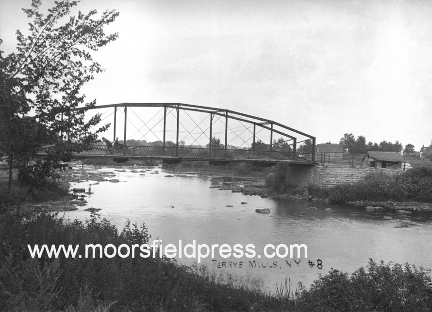
The “Lower
Bridge” in the Village of Champlain (Elm Street)
It is not clear when the Lower Bridge or Elm
Street bridge was built but it was likely built
during the winter of 1794 after it was approved
the by state commissioners. At the time, the
area along Champlain’s Main Street was completely
unsettled. With the bridge present by 1797,
Thomas Fox, who had come from England, built a log
cabin near the south end of the bridge at the site
of the former Champlain Hall brick
building. Afterwards, Amasa Corbin
built the first frame house on the flat and
operated a store. Charles Lewis Sailly
(the son of Peter Sailly of Plattsburgh) also
operated a store here. These were Main
Street’s first businesses and they could only have
flourished after a bridge was built to connect the
north and south banks of the Chazy river.
:
:
:
The “Upper
Bridge” in the Village of Champlain (Main Street)
The Upper Bridge was for many years only a crude
walkway across the Chazy river. Prior to
1811, Pliny Moore built a stone mill on the west
bank of the river where Main Street passes over
the bridge. This mill building stood until
1876 and was used as a mill, school, jail and
barracks for American soldiers during the War of
1812. It is commonly referred to as the “old
stone mill”, “clothing mill” or just “grist
mill”. In the early days, the only way to
cross the river here was on “string pieces” which
were hewn timbers tied together and supported by
piers in the river. This structure is
clearly seen in one of Pliny Moore’s maps.
To get their grain ground, people from all over
town would come to the mill by way of the Chazy
River and unload their boats at the lower bridge
where the riverbank gently slopes down at today’s
River Street. They then had to haul their
grain over the Elm Street bridge, pass through the
village flat (downtown Main St.) and cross the
precarious walkway to the gristmill.
:
:
:
The Bridges
at Coopersville
Coopersville was settled as a mill station.
Around 1805, Benjamin Mooers purchased lots where
the Corbeau Creek empties into the Chazy
River. He built a sawmill and gristmill on
the Corbeau and this area was referred to as
“Mooers Mills” until 1816. Afterwards,
Ebenezer Cooper bought this land and built more
mills. The area became known as Coopersville
and his Federal style house still stands on the
south bank of the river by the Route 9B
bridge.
On March 1, 1815, Benjamin Mooers wrote a letter
to Lieutenant Governor John Taylor and asked
that the legislature authorize the building of a
bridge near his mills. At the time, the
only bridge across the Chazy river was in the
Village of Champlain. This was an
inconvenient location as it required people to
travel 10 miles out of their way to get to the
other side of the river. Not surprisingly,
some people (probably merchants) in the village
did not want the bridge built because it would
reduce the amount of travelers passing through
the village. The same could be said when
I-87 bypassed Route 9 and Main Street in the
mid-20th century.
:
:
:
|