Essay: Champlain's Boat
Yards on the Great Chazy River and the Canal Boat Industry
(this is a partial history, see the
calendar for the complete essay)
The Great Chazy River has been a tremendous
economic engine for the village and town of
Champlain. The river winds its way from
Upper Chateauguay Lake and Chazy Lake and passes
through the town of Mooers and then into the
town of Champlain.
Boat building in
Champlain grew over the years and then
accelerated in the 1880s before peaking out
around 1910. Champlain Town was known as
one of Lake Champlain’s most important boat
building locations.
With an abundant supply of water and gentle
slope, the river was used to float timber to
downstream sawmills where they were sawed and
placed on sloops and canal boats near the
Rapids. By 1862, 20 million feet of lumber
was shipped from Champlain to ports in St. Johns
or Whitehall for use in house building or to
power the steamers on the lake. The need
for sturdy boats prompted Champlain’s early
industrialists to build their own.
The Town of Champlain had at least three boat
yards on the Great Chazy River that were used by
various partners over a period of 100
years. The largest boat yard was south of
the village of Champlain at the end of today’s
Gokey Road. This boat yard was built by
Royal C. Moore and Timothy Hoyle and was shown
as “Moore & Hoyle’s Wharves” on a 1857 map.
The second major boat yard was in the
Village of Champlain at the end of River
Street. This yard was probably first used
by the Nyes to build several boats and heavily
used starting in 1879 and known as “Kellogg
& Averill’s boat yard.” The former
“Moore and Hoyle” boat yard and wharves were
probably owned by them too. Boat building
also occurred at the mouth of the Chazy river on
the southern bank. Smaller boat yards were
surely built along the river by independent boat
builders.
In May of 1788, Pliny Moore, along with several
workmen and settlers, rowed a boat from the
headwaters of Lake Champlain to the Great Chazy
River and up to Perrys Mills. Moore showed
that the river was navigable by boat for at
least four or more miles upstream (the average
depth was seven feet up to the village).
During that summer, Moore rowed from his
mill site to St. Johns, Quebec to buy
supplies. In 1797, Elias Dewey and his
family sailed for a week on the sloop “Drowning
Boy” from Whitehall to Rouses Point when he came
to settle. In the 1790s and early 1800s,
only a few sloops and schooners were available
in Champlain as most people used canoes and
small boats (called a bateaux then). The
sloops were used by the early settlers to
transport grain, lumber and supplies to and from
Plattsburgh or St. Johns. Potash, which
was a sought after commodity in the early 1800s,
was transported to St. Johns for shipment to
England by way of Montreal. Sloops were
used to move passengers too. It took two
days to sail from St. Johns to Burlington in
1808.
The trade between the US and Canada on the Lake
Champlain-Richelieu River waterway prompted the
Quebec government to build the 12 mile Chambly
Canal to bypass the rapids on the Richelieu
River. Since the time of Samuel de
Champlain’s expedition to Lake Champlain in
1609, the rapids here prevented direct passage
between Lake Champlain and the St. Lawrence
River. The six foot deep canal was started
in 1831 and opened in 1843. Previous to
that, the 60 mile Champlain Canal near
Whitehall, NY, had opened in 1823 and connected
Lake Champlain to the Hudson River. With
the two canals opened, goods could be
transported from the St. Lawrence River to New
York City and to all ports in-between.
This opened up markets as far away as Quebec
City, Ottawa and New York City. Rouses
Point became an important customs port for the
import of goods from Canada and several docks
were built to house the customs houses
there. In 1860, the “F.W. Myers” company
in Rouses Point was established to handle the
customs brokerage business which insured that
all import duties were paid by the
shippers.
The Moore, Nye, Hoyle and Whiteside families
were some of Champlain’s earliest
industrialists. They operated sawmills,
gristmills, owned commercial farms and made many
finished products. They needed a good
supply of boats to move raw materials to their
mills and finished products to market. The
earliest commercial boat building project
probably dates to 1838. Freeman and
Bartlett Nye were merchants and needed boats to
ship their products to market. In 1838,
they built the schooner “Champlain” and Captain
George Brown sailed it between Champlain and
Whitehall (an 1841 receipt shows that it
transferred supplies at Point au Roche).
It is possible the Nyes built the boat on
land they owned on the north bank of the river
at the end of River Street (the site of the
sewage treatment plant today). Bartlett
Nye owned the property across the street where
his Locust Hill house was built in 1851 (the
future Savoy) and his property extended down to
the north bank of the river. Not
coincidentally, this area became Kellogg and
Averill’s boat yard in 1879 and Bill Earl had a
boat launch here circa 1909.
:
:
A 1908
government publication “Merchant Vessels of the
United States” listed all of the canal boats and
barges registered on Lake Champlain (most of the
boats in use had been built between 1880 and
1908). The town of Champlain had 104 canal
boats listed as being built since this time with
many more built prior to 1880 (many were built by
Averill and Kellogg). These boats include
the “Henry Hoyle”, “Joseph Lamountain” (1890),
“Joseph Allore” (1889), “Leon Robert”, “Armenia
Allore” (1882), “J.B. Allore” (1881), “Rosy
Allore” (1882), “W.C. Lafountain” (1908), “Frank
W. Myers” (1904), “J.R. Myers” (1908) and “F.W.
Avery” (1882) shown in a monthly photograph
here. Many boats built in Champlain were
registered in Plattsburgh or even in Albany and
N.Y.C. Joseph A. Allard (spelled
“Allore” on the boats) also built several boats
including the “T.M. Leonard” (1889), “Annie
Gannon” (1892), “Wm. C. Bloomingdale” (1897) and
“Laura Allard” (1902). A.B. Spellman, who
owned a store on Main Street in downtown
Champlain, owned several boats.
:
:
The “Averill & Clark” boat yards built more
than just canal boats. The boat yard also
built barges, passenger boats, yachts and
houseboats. In 1908, the boat yard built
Walter Witherbee’s luxury houseboat “Silouan”
which hosted President Taft and his family in
July of 1909 during the Tercentenary
celebrations in Ticonderoga and
Plattsburgh. A primitive gasoline-powered
automobile ferry called “The Twins” was also
built. The ferry was built in 1905
for William Nelson Sweet and operated between
Chazy Landing and Isle la Motte before the
Rouses Point bridge was built. The ferry
could hold five cars and was named for William’s
twin sons Clinton and Gerald. A second
15-car ferry was built in 1916 and he named it
the “Twin Boys”. This ferry ran until
1937. A 1910 newspaper article described
Sweet’s ferry business: “Capt. Will.
Sweet’s gasoline automobile ferry at Chazy
Landing is doing a fairly remunerative
business. Paring the heavy expenses for
advertising and supplies profits would be
normal. However, the Captain’s rates are
as low as can be expected with an aburdant
disposition to please all comers.” The
ferry was a well known tourist location and was
listed on early car maps.
:
:
Averill & Clark’s
Boatyard at Champlain.
View
on the Big ChazyRiver.
(Reprint from the Plattsburgh
Republican, July 18, 1908).
For over a quarter of a century [since
about 1883] the making of boats has been
an important industry at Champlain, New
York, and a large proportion of the
canal boats in use on the lake made
their first voyages down the big Chazy
River from that town.
The
boatyard, which is owned by Averill
& Clark, is located in the valley on
the north bank of the river [probably
near Gokey Road; see note
below].During the past
winter and spring two canal boats have
been built, the house boat owned by Hon.
Walter C. Witherbee has been completely
overhauled and two gasoline engines
installed, enabling her to be propelled
under her own power, and a new type of
gasoline ferryboat has been completed.From 20 to 30 men
had been employed in the building of
these boats.The work was done
during the dull seasons, so that
employment was furnished when it was
most acceptable.
While
the yards are busiest during the winter,
they are in operation throughout the
whole year.One boat is no
sooner launched than another is ready to
take its place, and so it has been for
over thirty years ever since the
industry was started by Kellogg and
Averill.
Long
experience in building canal boats has
developed a system of completeness in
the arrangement of the living quarters
of the vessel that would with good
reason excite the envy of a city flat
dweller.In the few square
feet available a kitchen, with its
range, pantry and all equipment divides
space with bedrooms, dining room and
parlor.There is not an
inch of space that is not utilize to
advantage.The finishing of
these cabins is often carried out to
suit the individual taste of the owner
in case the boat is being built to
order, as often happens.Otherwise the
same general plan is carried through all
the boats.
The
Witherbee houseboat [“Silouan”]is a
remarkably fine example of the designers
skill in getting the most in comfort and
convenience into a limited space.This boat is 90
feet overall and 17 feet 4 inches beam.In the center is
a passageway which extends from side to
side and separates the quarters into two
sections.Back of this is
the kitchen in the right hand corner,
and in the left-hand corner are two 10
horsepower gasoline engines which were
installed during the winter.Large tanks of
water are here placed and a system of
pure running water extends over the
entire boat.A 15 by 17 foot
dining room is just forward of the
kitchen.In the forward
section there are 10 sleeping rooms
which are models of convenience.The upper deck,
which is a most important part of the
houseboat, is equipped with all the
appointments of the most charming and
comfortable of piazzas. [President Taft
was hosted on this boat in July of 1909
during the Tercentenary celebrations.]
The
ferry boat built for use at Larabee’s
Point is a large vessel capable of
transferring two or three teams besides
a large amount of freight.It is a large
flat bottomed scow with a 10 horsepower
gasoline engine on either side midway of
the boat.At each end is a
steering paddle shaped along the natural
curve of the wood[A March 2, 1908
article noted: “Champlain: D.M. Tuttle
& Co., have placed an Ethan Allen
ferry boat, gasoline engine, 2 ton horse
power to ply between Ti and Larabee’s
Point.”]
The
ferry boat was placed in commission the
last of April.
The
yards are under the general supervision
of Mr. John W. Clark, who gives his
personal attention to all work that
passes through the yard.Edmund Poissant
Jr. (probably 1870-1946), is the foreman
of the plant and an expert boat builder.
The
fact that this yard is located in
Champlain makes considerable difference
in the population as some fifty odd
captains make their home there.Most of them own
their houses and are counted as among
the best and most substantial citizens
of the community.
-------------------------------------
Monthly
Descriptions (partial)
JANUARY: The
Whiteside Mill, Perrys Mills Road.The
abandoned Whiteside flax factory is shown
after a morning snowfall.The
factory was located between the north bank
of the GreatChazyRiver
and the Perrys Mills Road
directly opposite Gooley Road....continued.
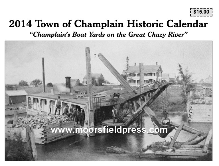
COVER: CoopersvilleBridge
on Route 9B, circa 1886.This
photograph shows a steam dredge removing
bridge debris from the GreatChazyRiver
in Coopersville.This
was certainly a primitive machine by today’s
standards but quite modern compared to Moore
and Hoyle’s horse dredge that was used to
dredge the Chazy river for many years.This
particular dredge had a metal shovel placed
at the end of a long wooden boom which was
raised and lowered by an iron chain with the
help of the steam engine.A
man used a large turn-wheel to pivot the
shovel.Children watched the action from the
north bank.In the background is the old Fesette
Hotel building which is now owned by Bryan
and Suzanne Moore....continued.
FEBRUARY: F.W.
Myers Brokerage Company and U.S.
Customs House, Lake Street,
Rouses Point.
"F.W. Myers & Company” was a customs brokerage
business.The
firm handled customs paperwork for the import of
goods into the United States.The
company was founded by an Irish immigrant named
John Myers who arrived in Rouses Point from Burlington
in 1845.Myers
worked as an agent for the railroad for 15 years
and realized that Rouses Point did not have a
customs brokerage business.In 1860,
he established a brokerage business with his son,
Francis W. Myers (1837-1908) and the business was
called “F.W. Myers and Co.”....continued.
MARCH: The “F.W. Avery” canal boat is shown
lodged against the drawbridge in Coopersville
after being swept downstream by ice and water.The boat
was pried from its winter mooring, and
unfortunately, the draw-bridge had not been
rotated.The
boat was likely salvaged as it was listed in a
1908 publication.
....continued.
APRIL:
This photograph was taken prior to 1905 and shows the LowerBridge
and the First National Bank.Most
interesting about this photo is the number of
people and boats on the Great Chazy river then.....continued.
MAY:
Station House, Hotel And
Steamboat Landing, Rouses Point, New York,
Ballou’s Pictorial of Boston, January 9, 1858
The Station House Hotel
was a large railroad depot, steamboat dock
and hotel built on a 620 foot long by 100
foot wide wharf in Rouses Point. The
Rouses Point Beacon
noted that the hotel was the “the
mightiest edifice of which Northern New York
can boast."The first floor housed the depot,
customs house and a large sitting room for
guests.A dining saloon was on the second
floor along with hotel rooms.It
is interesting to note that after a formal
meeting of railroad men at the hotel, there
was not a dissenting vote on whether to
retire to the saloon for drinks.Railroad
tracks ran to the depot and a second set of
tracks ran from today’s Manor
Drive and
entered the lake at another wharf a few
hundred feet south of the hotel (this is the
newly refurbished state dock).In
the 1850’s, the Champlain and St. Lawrence
Railroad built railroad tracks on 3,000
piers that ran three-quarters of a mile
along the shallow shoreline from the hotel
down to Champlain Street.At
the end of the tracks was another customs
house.The tracks and customs house are
clearly seen in Ballou’s Pictorial drawing
as well as the 1857 Ligowsky map but had
been abandoned and removed by 1863.The
huge hotel was destroyed by a tornado in
1870. Today,
the wharf is filled in with dirt and a road
extends to the end of the pier.The
pier is owned by the Rouses Point
Sportsman’s Club and is located off Montgomery
Street.
Ballou’s Pictorial of
Boston
January 9, 1858
The brilliant picture below was drawn
for us upon the spot by Mr. Kilburn, and
faithfully represents one of the most
interesting localities in the United
States.In
the view we are looking south.At
the point where the steamboat is lying in the
distance is seen the depot of the Champlain
and St. Lawrence
Railroad.The hotel which appears in the right of
our view is situated at the extreme point of
the pier, and adjoins the station of the
Ogdensburg Railroad, which is not represented
in the picture.Rouse's Point is located in a very
level tract of country, the whole region being
flat and unpicturesque, and but little higher
than the level of Lake
Champlain.The
land upon which the fort in this neighborhood
was commenced, was ceded to the United
States by
the Ashburton treaty.The
fort is now in the process of completion,
about three thousand men being employed on it.The
village makes a very pretty appearance as it
stretches along in the distance, with its
chimneys and trees reflected in the water.The
village is in Clinton
county, and at the head of Lake Champlain, at
the extreme northeast corner of the State of New York.
The cars of the New York Central Railroad
cross the lake by a bridge upwards of 5,000
feet in length, the center of which, almost
300 feet in length, consists of a species of
boat or floating
bridge, so arranged that the passing
of the cars is not affected by any rise or
fall in the water.Except
when the cars are crossing, it is kept open or
swung round, so as not to interrupt navigation
on the lake.The cost of the bridge, independent of
the floating portion, was about $300,000
dollars.Lake Champlain
is about 130 miles in length.Its
breadth varies from half a mile to ten miles,
and its depth from 50 to 280 feet. If we
include the expanse embracing the large
islands, the breadth in its widest part will
amount to 15 miles.Its
coast line, including all its windings and
turnings, is estimated at 280 miles.The
principal streams flowing into it are the
Saranac, Chazy, Au Sable, Missisquoi, and
Winooski, the outlet of Lakes George and Wood,
and other creeks.Its
principal outlet is the Sorel
or RichelieuRiver,
which discharges its waters into the St.
Lawrence, about 50 miles below Montreal.
It contains many islands, among which may be
mentioned North and South Hero, La Motte and
Schuyler. The Vermont shores of this lake are
for the most part fertile and highly
cultivated, while those of New York are wild,
rocky and barren, rising into vast mountains,
interspersed with lakes, but containing few or
no bottom lands.In favorable weather, Lake Champlain
presents to the traveller views of surpassing
beauty and magnificence, many of the principal
peaks, both of the Adirondack group in New York, and of the
Green Mountains in Vermont
being visible from the steamboats as they pass
from one extremity to the other…..[continued]
JUNE:
The Pliny Moore House and Presbyterian
Session House, Village of Champlain.
This is
one of the most unusual and rarest images
showing the Oak Street-Elm Street
intersection in the Village of Champlain.The
image was made in the 1850’s or early 1860’s
and shows a view common to other scenes of
this intersection but with many subtle
differences and one striking omission.In
this view, the First National Bank building
is not present nor are any other buildings
present here......continued.
JULY: Main Street,
Village
of Champlain
The Village of Champlain
has always celebrated July 4th with
parades and festivities.In
this parade on Main Street
in 1908 or 1909, a horse is shown pulling a
makeshift float.
AUGUST:Champlain’s
biggest boat yard is shown with a houseboat and
canal boat under construction.A
barge is moored next to the canal boat.This
is one of the best photos seen of this boat yard
which was probably at the end of Gokey Road.Behind
the boats were numerous buildings that were used
for tools and storage.Piles
of lumber lay near the boats as well as the
partial hull of a future canal boat.Today,
there is no trace of any of these buildings.....continued.
SEPTEMBER: A houseboat sits
anchored next to a barge at the Averill &
Clark boat yard.This boat was shown under construction in
the previous month’s image and could be the C.E.
Johnson houseboat ‘Winona’ as described here:
“The Johnson houseboat ‘Winona’ which has been
in the course of construction for the past three
months at the Averill and Clark boatyard, left
under its own power for Plattsburgh Friday
afternoon.”....continued.
OCTOBER: The Witherbee Houseboat
“Silouan” at the Averill & Clark Boat Yard,
1907-08 In 1907, Hon. Walter Witherbee
of Port Henry commissioned the building of a
huge houseboat by the Averill & Clark boat
yard.The
boat yard made many houseboats and yachts for
Lake Champlain’s
wealthiest residents.Surprisingly,
architect Hugh McLellan was asked to design
Witherbee’s houseboat.McLellan
had only been a practicing architect for about
three years in New York
City but did work in Champlain, Westport,
Rouses Point and other places around the
region.An
April 1907 blueprint shows the design of the
houseboat.....continued.
NOVEMBER: Champlain’s canal
boats and barges played a prominent role in the
1909 Tercentenary celebrations.Boat
builder James Averill conceived of tying
together six barges to create a floating
exhibit.Starting
in February of 1909, he corresponded with L.
Armstrong of the Canadian-Pacific Railway in Montreal
who was appointed to work with Averill on the
exhibit.The
budget for the exhibit was $12,000 and an
expense list shows the costs of the supplies to
make the props (30,000 feet of spruce flooring,
Oregon pine, oak timber, spikes, rope, bales of
cotton, 125 pounds of white lead, canvass for
the painted backdrop, etc.).An
elaborate Indian village was designed and built
on the barges and 200 Indians from Canada put on a
pageant in front of waterfront crowds in Burlington, Isle la
Motte, Plattsburgh,
Crown
Point and Rouses
Point.Some
of the correspondence centered around taking the
barges down to New York
City for the Hudson
celebrations.An April 1909 newspaper article described
the floating pageant: “…Two hundred Indians will
be used in the pageant and the marine stage will
be built upon six barges which are already under
construction at the boat yard of Averill &
Clark at Champlain.These
barges will be joined together by platforms,
making a craft resembling a catamaran.The
whole will be transferred into a floating island
with rocks, trees, Iroquois log-houses, lodges,
etc.”A year after the celebrations
Tercentenary committee member Walter Witherbee
advertised the barges and told Averill he had a
number of inquiries.
DECEMBER: “Allason Block” Building,
Main
Street, Village
of Champlain
One of the most enduring and still occupied
buildings on Main Street
is the former “Allason Block” building.The
building was built prior to 1862 by William B.
Allason who was a businessman, canal boat
owner and passenger conductor on the
Ogdensburgh and Lake Champlain Railroad until
his death that year at the age of 42.The
building was passed to his wife, L. Jane
Allason, who lived on the hill on Main Street
in the house that later became the house of
Dr. Hackett (afterwards, it was bought by St.
Mary’s church and converted to a convent
before it was torn down.)....continued.
Read about the 2014 Champlain Historic
Calendar in a local newspaper.
This calendar, with a
15 page historical essay will benefit the Glenwood Cemetery
Association of Champlain.
It can be purchased at many locations in the
Champlain and Plattsburgh areas.